Mount Mansfield

A great mountain hike, best seen as a package deal.
Mount Mansfield, I thought, was named so because it famously seems to fit the profile of the human face. It turns out that it was named by settlers who came from another Mansfield in Connecticut, as it was the custom to name the new settlement after where folks had previously lived.
When I first read this, I thought, how unoriginal (meh). But, we see this all over the country, even the world. Although, I have to say that in the Northeast it seems very prevalent. I guess it makes sense – when they were settling in the seventeen and eighteen hundreds, 60 miles was a long way to go and it didn’t seem weird to have two towns with the same name. I guess that’s why you can go on a little family road trip and see the same town name pop up again and again. Back to the hike…
Mount Mansfield, in Underhill State Park, VT is a beautiful mountain within a short drive of several quaint little towns. The hiking route I took was fantastic, but there are plenty of other trails to check out. There is also the option of driving most of the way to the “Chin” by way of the Toll Road, or by easing the amount of ascent required by taking the gondola from Stowe.

I don’t know what else to say about the towns that you drive through other than they are quintessential New England. Small, charming and welcoming. If you have the time, stay the night or even the weekend. You can do a couple hikes, like Mansfield, the Long Trail, and the Camels Hump. Then you can eat and drink the calories you burned at any of the great breweries like the von Trapp Brewery, the Alchemist or Smugglers Notch . Don’t forget Ben and Jerry’s Factory and the Cabot Cheese Farmers’ Store!

If you are into history and you think snowflakes are beautiful, you can also visit Bentley Museum in Jericho which will likely be on your way to Mount Mansfield. Bentley was a snowflake photographer who lived between 1865 and 1931. He captured more than 5000 images of unique snowflakes, each a superb demonstration of both beauty in nature and that beauty can be fleeting.

All in all, a Mount Mansfield is a great way to spend an afternoon. Although it may be a bit if a drive to get to for some folks, when you consider all the additional attractions and are willing to do an overnight, it becomes infinitely more appealing.
One last note before I get into the details of the hike: I drove up on a Friday morning from Massachusetts (3 hrs), started Mansfield around 11 AM, finished around 2:30 PM, ate lunch, drove to Camels Hump (only 30-40 min away), hiked, and was done just after 7 PM. If you are up for feeling the burn, the two mountains are definitely doable in one day if you are okay with pushing the pace (between 20 and 30 min/mi). I was introduced to this hike and the Camels Hump through the Six-Pack of Peaks Challenge.
Course: At Underhill State Park, CCC Road (can take Eagle’s Cut), to Maple Ridge to the Long Trail to Sunset Ridge to Maple Ridge to CCC Road.
Start Date and Time: Friday 8/02/19 at 11:08 AM
Weather: Sunny 73 degrees F, Sunny
Total Distance and Time: 7.93 miles (Garmin) for 3 hours, 21 minutes (with some running).
Elevation gain: 3099 ft elevation (Garmin)
Clothing: Sweat Heads Yeti Trucker Hat, buff with bug repellant, short sleeve moisture wicking shirt, shorts, compression sleeves (legs) and ankle height running socks.
Food and Gear: I wore an Ultimate Direction Vesta 2.0 with 1.5 L bladder. I brought one waffle, a pack of peanut butter crackers and two gels for food. Just in case, wipes and a carry out bag, compass, maps of trails, phone, mace, multi-tool and matches. I wore Brooks Cascadia 13. I also had my Garmin Forerunner 35.
Additional Information: I wish I had brought an electrolyte drink on the hike. With the temps and pace it was definitely warranted. I had some when I got back to the car, but it would have been better on the hike.
Arrived just after 10:30 and started the hike at about 11AM. I think I got the next to last spot in the parking lot. After you park you have to go to the ranger station to get your parking pass which $4 last check. There is a bathroom (very nice and clean) and potable water near the ranger station.

You can access some of the high points of the mountain with less hiking by taking the Toll Road to the visitor center, or taking the gondola from Stowe and hiking a little further up. However, these routes will cost you $$. The “chin” is the highest point, and some hiking is required no matter what to get to it.

The Hike:
After posting my parking permit in the car, I geared up and head out on the Eagles Cut Trail. Eagles Cut intersects the CCC Road which is laid out like a switchback and has very easy footing until you get to the Maple Ridge intersection. If you wanted a shorter route and you don’t mind a classic rugged trail with roots and rocks, Eagles Cut for most of the initial ascent is another way to go.

Upon reaching the Maple Ridge intersection, the CCC Road hangs right and becomes less of a road and more of a trail. After a pretty constant ascent and a few peek-a-boo views, the trail offered a nice reprieve with a descent for about a quarter mile. At the end, the trail makes a sharp left, becoming Maple Ridge and the real climb begins.

Maple Ridge was a true hike! Lots of rocks and roots and steady uphill movement. On this section of the hike the trail will take you over a large boulder where the effort required is closer to rock climbing. I can see it being challenging to get dogs up if you bring yours. However, it did appear off to the side that there might be a wildlife path that some folks have been using to get around it. In addition, the Maple Ridge Trail offers a point to point jump over a five to six foot deep gap that is about 2.5 to three feet wide. If the jump seems a bit much, you can straddle it and push off instead. Sometimes we slide, we scramble, we fall gracefully…no judgement!:-)


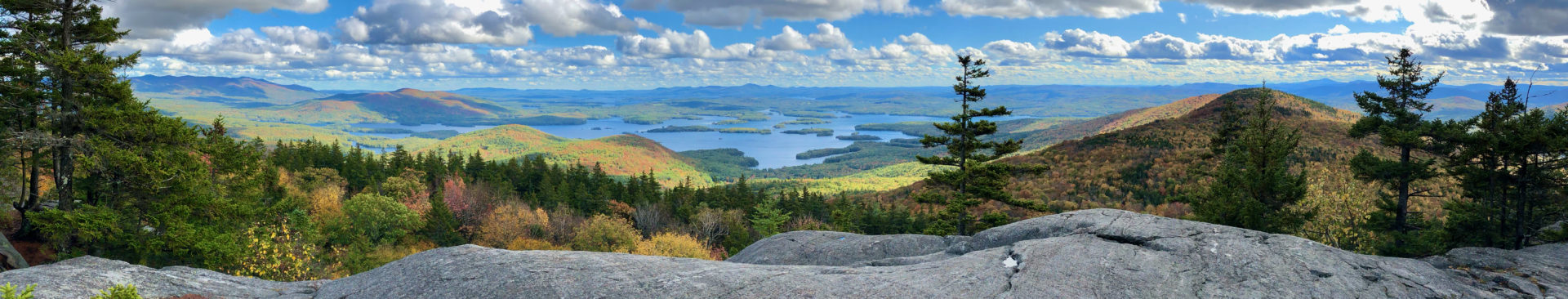
While ascending Maple Ridge you will find the views to be outstanding, with each new one surpassing previous. As you get closer to the Forehead, Maple Ridge joins with the Wampahoofas.
Once I got to the “forehead,” I headed north on the Long Trail. The smells on the trail were heavenly… the evergreens! I was thrown for a loop when the Long Trail intersects a service road and you are directed to take a left. I thought the trail would hit all the major “face” points, but to get to the “nose,” (which has a cell tower or two from the looks of it), you would have to follow the service road. To follow the Long Trail, you make a left down the service road and then a right back onto a single track.

Shortly after rejoining the trail, you come across the visitor center which can be accessed by the Toll Road by car. From the visitor center all the way to “chin”, the traffic was considerably higher as a result. I can’t imagine what it would be like on a weekend!


Down Sunset Ridge was great. A few steeper spots, but glad I was going down Sunset instead of Maple Ridge. Also, so thankful that most areas were dry. Sunset Ridge has a considerable amount of exposed rock for the descent for the first half, so on a wet day I imagine one would need to be extremely careful.
Once back under the shade of trees on Sunset Ridge, there were lots of rocks and roots to hop around. Fears of falling flat on my face subsided once the trail got within a quarter mile of CCC Road.
Awesome trail, tons of fun, challenging and totally worth it! Would love to go back and try some of the other trails on the mountain and bring my boys. The trails were very well marked and taken care of. Thank you thank you thank you to everyone who has contributed to the care of the trail system on the mountain.
Also, the area is great- perfect for an active weekend getaway. Lots of stuff to do, lots to drink and lots to eat!
Sources for article:
http://www.city-data.com/forum/massachusetts/2603138-most-popular-town-names-new-england.html