Mount Lincoln
Hiking the Franconia Ridge Loop
While the hike is called “Mount Lincoln” it is really a hike that encompasses three of New Hampshire’s 4000 footers, Little Haystack, Lincoln and Lafayette, all of which are on the Franconia Ridge Trail. Seeing as Lincoln is right in the middle, makes sense to call it the “Mount Lincoln” hike to match all the other Six Pack of Peaks Challenge. But, if you are looking for trail info and how to get to Mount Lincoln, you want to focus on the Franconia Ridge Loop and Franconia Notch.

The whole loop consists of three trails, the Old Bridle Path, the Franconia Ridge Trail (which overlaps with the Appalachian Trail) and the Falling Waters Trail. Before I went, I read up on which path would be best to start on, Falling Water or Old Bridle. It seemed to be split 50/50. Mount Lafayette is the first and tallest peak of the three, and because I like to get the majority of my elevation in earlier rather than later, if I can, I went with Old Bridle where I would hit Lafayette first. Did I make the right choice? I don’t know. I am definitely going to hit this one again, trying the opposite direction next time to be sure. I think determining which way is best would come down to if you mind having wet feet. If you don’t, up Falling Waters first is probably best because the views would be better and the terrain is much more forgiving as an upward trek rather than down. Plus, the wet is just wet – I didn’t find it to be slick. I’ll update after I try going counterclockwise next time.
Overall, I found this hike to to be quite enjoyable with a good bit of challenge thrown in. I was a bit tired from hiking Mount Washington earlier in the day, but the trail is more than doable for most folks as long as you are in a for a few fun scrambles, don’t mind traversing streams and are all set for the lunge workout of your life:-).
Course: From Franconia Notch State Park, up Old Bridle, to Franconia Ridge Trail, down Falling Waters.
Start Date and Time: 9/6/19 (Friday) at 12:53 PM
Weather: 70 degrees F, mostly sunny at trailhead, mostly cloudy and windy at summit, closer to 50’s.
Total Distance and Time: 8.56 mi 4 hours and 34 min, elevation gain 3822 ft (Garmin said 4105 ft). This was with some running and picked-up hiking.
Clothing: Shorts, short sleeve shirt, compression sleeves (legs), crew socks (regretted this after— need longer socks), Sweatheads Yeti trucker hat, and a buff.

Food and Gear: I wore an Ultimate Direction Vesta 2.0 with 1.5 L bladder and 750 ml soft flask filled with an electrolyte drink. I brought two waffles and two gels for fuel. Just in case, wipes and a carry out bag, compass, maps of trails, gloves, beanie, jacket, phone, mace, multi-tool and matches. I wore Brooks Cascadia 13. I also had my Garmin Forerunner 35.
Additional Information: When you park at Franconia Notch State Park for the Lafayette Place Trailhead, there are two parking lots that are only accessible from their respective sides (N/S) of Route 3. So if you pick one and it is full you have to get back on and go north or south to the next exit to make a u-ey. If you are going south on Route 3, you will end up at the Lafayette Camp Ground where after you park you have to go under Route 3 and up a slight hill to the get to the trailhead. Going north will have you right next to the trail head. I was going south on 3 and ended up parking at the campground- I think I was lucky to get a spot! As with most places, the word on the street is to get there early. I also saw something about $3 for parking, but didn’t see any signs or booths or anything for it when I was there. Maybe it was because I was at the campground lot?

Also, near the start of the trailhead there are bathrooms – score! But, I do not recall if there was water.
This is a very busy trail head, or at least it was at mid-day. The majority of folks seemed to be going up Falling Waters and coming down Old Bridle.
The Hike: After leaving my car I walked through the tunnel underneath Route 3 and up a slight hill to get to the trail head. I got my bearings, headed up the trail and quickly turned left to take the Old Bridle Path to Lafayette.
Old Bridle Path meanders back and forth with many roots and rocks, although there are plenty of soft dirt patches to land on. I kept a steady pace in-between frequent breaks to take in the views and to check out the best routes for scrambling up rocks (of which there are several). The grade was pretty consistent with the exception of the rock scrambles.


Just short of three miles, I arrived at the Green Leaf AMC hut. I wanted to keep the momentum going, so I didn’t stop. Next time I would like to because looks like a perfect place to take a break!

The trail slopes down from the hut for a short bit before starting the uphill climb again. I made my way through a smaller thicket of evergreens where the trees were just big enough to make you feel protected. Time in the evergreen grove was quick and soon I rose above the little forrest and could see the climb to Mount Lafayette that awaited me. While less boulder like in comparison to Mount Washington, the way up Lafayette was all about rocks, rocks, and more rocks. Big, small and some scree. Also like Washington, the distance was deceptive. You wouldn’t think it was nearly a mile from clearing the trees to the top of the Mountain.

As I was nearing the peak of Mount Lafayette, I saw two Chihuahuas, (with their people). The Chihuahuas, in little backpacks, were adorable, but they looked cold and scared! If I were to give this hike a nickname, it would be the hike of the dogs because in addition to the chihuahuas I saw a bunch of collies and two labs. All these dogs looked like they were made for this loop. I would love to bring my Boston terrier, but for one, I don’t think he would listen well enough to be on a trail with all the bustle, and two, he would definitely get to a point where he would refuse to go further and I’d be stuck carrying him. Maybe one day? No- probably not:-)
As I was passing the Chihuahuas, the clouds started to roll in. Off in the distance weather looked amazing, but from where I was and leading up to the peak it was getting windy and chilly. I was glad I packed my jacket! I put it on and kept on truckin’.


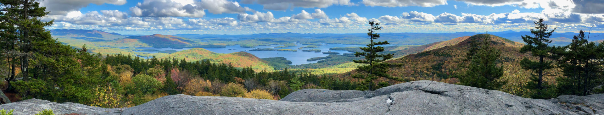
Mount Lafayette was beautiful on this, now, windy and cloudy day. I imagine it would be spectacular when it’s clear. With the wind whipping, I quickly took in the views from every angle with a few pictures so I could relive the majesty later on, and off I went down Franconia Ridge.


Dropping down the rocky path, I was surprised how little I had to descend before the wind seemed to die down. But, it was short-lived as Franconia Ridge is an undulating trail. The overall elevation from north to south declines, but you do end up “peaking” several times. There is Mount Lincoln, of course, but then there are several unnamed little peaks in between. For the most part the terrain is rocky, with some few and far between steep sections, and alpine growth on either side of the ridge.

By the time I made it to Little Haystack, the sun was making a play at peekaboo. Another few pictures, and it was time to go down Falling Waters.
Almost immediately I found myself in the forrest again, navigating gnarly tree roots and giant rocks. For most of this hike, the size of the rocks and the grade of the trail made the trek a lot like climbing stairs. That is, until here. Falling Waters is unique in the size of the rocks and their location. While the first part of the hike was like a regular Stairmaster, Falling Waters is more like a Stairmaster for those 8ft and taller. Think lunge-like steps and you get the picture. It was during this part of the trail I thought trekking poles would be splendid. Alas, I was without. Whether up or down, this trail is a lunge intense part of the hike.

Falling Waters does not disappoint insofar as its name. I do like water features on my hikes and was excited to see what the trail would bring. Although I can thankfully say I have never been in a position to be dying of thirst, I find that knowing that water is nearby is reassuring. The noises created from babbling brooks to even crashing waterfalls are calming. Not to mention, water features are beautiful to look at. However, I was not quite mentally prepared for needing to cross a brook, in this case, Dry Brook (ironic on this particular day). I believe that normally the water level isn’t as high and it is easy enough to rock hop (even more so with trekking poles, darn-it!). Today though, I was destined to get wet.

The beauty of the falls made the wet feet forgivable and even unforgettable. Deep down inside I think once I cross the clean / wet-dirty-stinky threshold my mind switches to “game on,” and everything else about the hike or run becomes that much more fun. Bring on the wet, dirty, stink!

Falling Waters to the Old Bridle Path junction is about three and a half miles where after two miles the water crossings will occur, and they will do so several times for about a mile or so. After that, it is a fairly straight forward everyday trail through the woods heading back to the parking lot.
This hike is one of the many in the Whites with spectacular views, but what I think might make it special is that it’s the hard hike you didn’t expect, where the hard makes it all that more rewarding. Mount Washington usually gets all the press because of its bad-boy weather, and well, it does have some bragging rights being the tallest peak in New Hampshire. However, both of them have spectacular views, both have total trail distances of pretty decent lengths (8 mi plus unless you are going one way on Mount Washington), and both are near 4000 ft of elevation gain. It is a hard trail, but doable as long as you have the right mind set and have prepared properly. The Franconia Ridge Loop may not have a bumper sticker, but it’s the unhyped trail you want to add to you list of must do’s in the northeast.
On a side note, I was, and still am curious why Lincoln is on a shorter peak than Lafayette and also why he didn’t get in the Presidential range? Should a true Presidential Traverse hit Lincoln, too? It might add 20 miles but, why not?!?