Baxter State Park, ME
Hiking Chimney Pond, Helon Taylor, Knife Edge, Saddle, Northwest Basin and Russell Pond from Roaring Brook Campground

I was drawn to hike Mount Katahdin in Baxter State Park by the Six-Pack of Peaks Challenge . Being five hours away from where I live and a “bonus” peak for the challenge, I almost didn’t do it. Fortunately, things worked out and I am so glad that they did. Hiking in Baxter Park was phenomenal. I have to admit that with each hike in the challenge, I was taken aback by how beautiful my surroundings where, the challenge of the trail and the views from the peaks. However, Katahdin being my last hike of the group was rightly placed.
Hiking Katahdin and then some in Baxter State Park provided a great physical challenge with an elevation gain of 5600 ft over 21 miles (nearly 4000 ft of it within the first four + miles). It provided a mental challenge on the Knife Edge Trail, where at least at the beginning near the chimney, it’s more than just putting one foot in front of the other. Also giving challenge were the Northwest Basin and Russell Pond Trails when trying to gage how to cross a deep stream or find the trail again, things I had not really had to do at all or nearly as often as I did there. This isn’t to say that the trails aren’t well marked. There are blazes and cairns all along the way, but it is worth noting that because these trails are not often traveled, there are a few sections that may give pause due to water collection, downed trees or game trails. That I was challenged to figure out the next steps at some locations was part of what made the trail so much fun. I liked engaging my brain a bit to figure where I was and where the trail would most likely be going and then voila! I found where I needed to go.

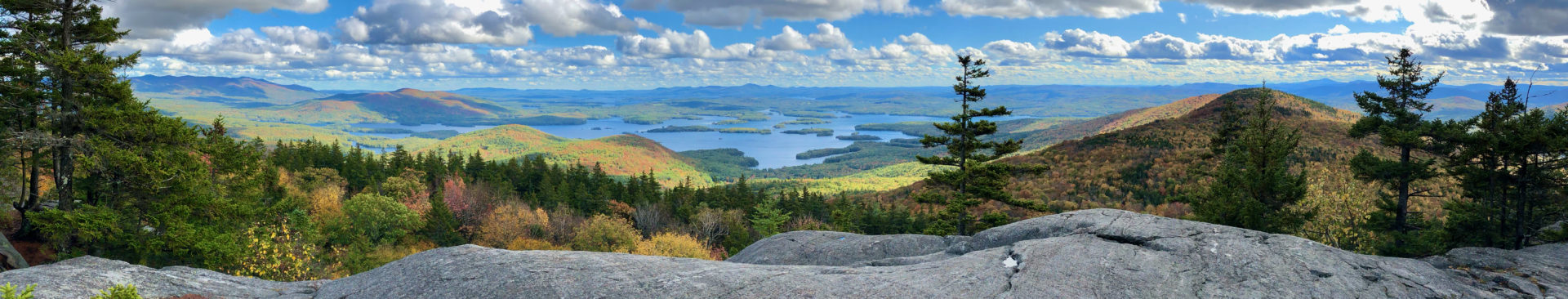
Katahdin also served up some of the best views yet. The leaves were just starting to change, the summit was in and out of the clouds and there were water features all throughout the hike. This park was also one of the more social places I visited this summer. Lots of energetic folks enjoying their hike and happy to share information about the trails they had been on.

If you are thinking about a hike in Baxter Park on Helon Taylor, Knife Edge, Northwest Basin or Russell Pond, there is info below about what you might encounter. I really wanted to post something because I found so little on the Northwest Basin and Russell Pond Trails before mu hike. I hope this helps! If you have any questions, feel free to email me at lifegotag@gmail.com. Happy Hiking!
Trail Course: Loop starting from Roaring Brook Campground via Chimney to Helon Taylor to Knife Edge to Saddle to Northwest Basin to Russell Pond to finish at Roaring Brook. You can find a version of what I did at the Hiking Project under Katahdin Loop or Alltrails under Russell Pond and Northwest Basin Trail Loop and their Katahdin Loop. For the Alltrails trails linked, combined they cover the trails I used, but they also use Saddle and Chimney heading back to Roaring Brook, which I did not.
Total Time: Summit was about 3 hours 30 minutes and total loop time of about 10 hours 30 minutes.
Start Date and Time: September 27, 2019 at 7:50.
Weather: The temps ranged from 40’s to 50’s. Winds at the summit were forecasted at between 25 mph and 35 mph, although it felt stronger on the Knife Edge.

Clothing: Wore a beanie, buff, sunglasses, long sleeve shirt, windbreaker, gloves (with grips), capri leggings, compression sleeves (legs) and ankle socks. When the wind whipped up my jacket and shirt, I felt a little chilly. I had to take off the jacket because it was getting too warm on the Northwest Basin Trail, but other than that, I felt the rest of the clothing was perfect. The buff around my neck helped with the bugs and also kept me warm. The gloves kept my hands warm up top and helped protect my hands if and when I would slip slick rocks. Having my legs covered completely, especially the lower halves, kept me warm, kept the bugs away and also from walking out of the park with some pretty significant cuts (the bruises were quite nice on their own).
I also packed an extra shirt, socks and a brimmed hat with me. I switched the beanie for the hat, but kept the long sleeve shirt on. To change socks seemed pointless as there was water everywhere on the Northwest Basin and Russel Trails.
Food and Gear: I wore an Ultimate Direction Vesta 2.0 with a 1.5 L bladder filled with water, a soft flask filled with electrolyte drink (750 mL), three GU gels, 3 Cliff Bars, 2 Honey Stinger Waffles, 1 PB and J sandwich, a compass, foil/thermal blanket, matches, Lifestraw, headlamp, extra batteries, maps of trails, wipes and bag to carry out for possible #2, multi-tool, mace, car keys, and phone. I can’t tell you how much it weighed loaded up, but I can say that the only time I noticed it was when I was sliding down a rock and I felt it catch.
I should have had more to eat and drink, but I ended up eating the two waffles (they always seem to go down easy), two of the gels and all of my liquids. No excuse…should have consumed more.
Additional Information: Baxter State Park is a decent drive from most places. If you have less than a quarter tank when you get off 95 driving there (if that’s your route) I would recommend filling up at one of the gas stations close to the exit. At least one of them is open 24 hours.
Before you go, it is also advised (not by me but park officials:-)) that you make a parking reservation ($5) and if you are from out of state, each person needs to pay $15 to enter. If you make a reservation, you need to be present before 7:05, because that’s when they start to give away parking spaces to those who didn’t have a reservation. On busy weekends, the chances are slim to none that you can get into the park without a reservation. Another option is to get there the day before and camp. Although, I ran into a guy on the trail that had a camping reservation the night before, but got there at 9pm. The park hours are 6am to 8:30pm, so he couldn’t get in:-/. Also worth noting, the line builds up at the gatehouse. I arrived in line at about 6:45 and didn’t get to the gate until 6:58.
The speed limit is 20 mph in the park and it took around 20 min give or take to get to Roaring Brook campground from the gate. Worth noting if daylight time is tight. Also worth noting if you get in your car to leave at 8 or so – you might arrive at a closed gate and need to stay the night.
There are outhouses at the campground, but no water stations so bring all you can or a way to treat the water. Also, it’s a carry in carry out. An extra bag for trash isn’t a bad idea.

For reservations and more info about the park and trails click here to get to the Baxter State Park website.
The Hike: After checking-in at the Ranger station and chatting for a bit about the conditions, I started up Chimney (about 0.1 mi) before veering left onto Helon Taylor (which I have been told is pronounced just like Helen). Helon starts with rocks and roots, but pretty easy to navigate. It had rained the night before so it was a little wet and marshy in some areas. There is a solid elevation gain, with two sections where the trail levels off and even descends a tiny bit. At about 2 miles in, it starts to open up. The views are amazing. It being late September, the leaf colors were starting to pop making it nearly impossible to not stop several times to take it all in.

You might think you are on the Knife Edge towards the end of Helon Taylor with the way the landscape is starts to look. The drop off on either edge starts to get steeper and the rocks/boulders bigger. For this section until the summit I highly recommend gloves – with grips would be great. The rocks up there are what I would describe as “grippy” and for that reason I would not wear knit gloves (lest you want to snag non-stop).

Helon Taylor intersects with Dudley and Knife Edge at Pamola Peak. Dudley is currently (as of fall 2019) being worked on and is not an option for a descent should you look at the Knife Edge and change your mind.

From Pamola, Baxter Peak hiding in the clouds. The north side of the Knife Edge at the chimney Baxter Peak shrouded in clouds as seen from the Knife Edge Looking down at the base of the chimney. The depth is hard to see in the picture, but just to the right of the hiker is a blue blaze, but it as about 20 ft down and 20 ft out.


The Knife Edge, in my opinion, lives up to its reputation. It is intimidating and if you were to let yourself get carried away with “what if” thoughts, it’s going to be a very difficult if not impossible trek. The day I hiked the winds were forecasted to be between 25 and 35 mph. It felt like more than that when I was on the north side of the edge . In some parts it felt like my beanie was going to come off. All that being said, I think the first 1/3 mi to include that first drop and then the chimney plus a few more challenging parts are the worst of it. The last 2/3 I thought were similar to the end of Helon Taylor. Bouldering before going on this trail might be helpful to build confidence with some of the movements and holds at the beginning. At 5’6″ I felt I was closer to the minimum height to do this solo. If you are shorter, you might appreciate the assistance of a push or pull from a partner as you start the climb of the chimney.
At the top you’ll keep company with the clouds …and a pretty stellar group of hikers.
Baxter Peak was busy with folks coming from the Hunt Trail (AT) , Saddle Trail and the Cathedral Cut-off. It was cool to see some of the folks finishing up their thru hike. It’s also a cool peak in that on one side it’s almost like a sheer cliff and on the side a gentle slope with grass waving back and forth in the wind. An interesting juxtaposition at a high peak.
View from Baxter Peak View from Saddle Trail just north of Baxter peak looking back at the peak. View from Saddle Trail just north of Baxter peak towards Hamlin Ridge View up towards Baxter peak off of Saddle Vegetation off of Saddle All kinds of different rocks on this mountain- little rocks to big rocks, you’ll see them all.


I took Down Saddle to Northwest Basin. Saddle is all exposed and full of all kinds of rock sizes. A beautiful descent with a view of Hamlin and Katadin with Pamola Peak in the distance. Saddle will depart to the east and to go north puts you on Northwest Basin Trail.

Once the Northwest Basin Trail leaves the Hamilin Ridge Trail (which heads east up to Hamlin peak), you can see it is one that not too many traverse. Despite this, above the tree line the blazes and cairns are easy to spot. Near where the trail hits the first of two major descents, the trail converges with a downhill stream. If it hadn’t rained the day before, it would likely just be wet and slippery with leaves and moss. It is extremely slippery for about a half mile. When the trail starts to level off, you find yourself at Davis Pond. This is an excellent place to take a picture as you are looking straight up the side of a mountain – but don’t stay in one spot too long as the bugs will swarm you!
The trail makes a sharp turn to the left and slightly uphill where you will travel on beams of wood off and on until you get to Lake Cowles. This was a tricky part as the trail seems to end, but really it was submerged. Perhaps it was because of the rain, but I would expect that normally, at a minimum you will have to do some rock hoping. However, you might want to prepare to trek through the water directly across the lake to get back on the trail.

Shortly after the lake crossing, you start the second major descent, although this one is little easier because the water flow runs parallel instead of in sync with the trail for more of the descent. The two miles including the two descents took me about two hours due to the need for very careful footing. I did not have trekking poles, but wish I had.
When the grade decreases again you’ll travel about a mile until your next water crossing. This is another tricky area where I had trouble locating the trail and/or blazes. If I remember correctly, I crossed the stream from one bank to another three times over maybe 30 yards. It required some rock hopping and I also ended up going in the water.
After the water crossing, the trail runs somewhat parallel to the Wassataquoik Stream. The trail has many marshy and stream-like sections as well as several smaller stream crossings. Around a half mile out from Russell Pound and after you have passed the intersection with the North Peaks Trail, you will cross the entrance to a pond (more rock hoping or wading). Overall, this section of the trail is pretty easy going as long as you don’t mind the marsh and getting wet. I was able to run a good part of it which was lovely- it’s nice to shake up the stride!

Russell Pond Trail is a pretty consistent undulating trail. There were numerous stream crossings with three of them being what I would consider major. Going south, the first two happen within about a mile of each other. I assume the water level was higher than normal and swifter than normal due to the rain and may be traversed by rock hoping normally, but when I crossed, I got in the water, leaning into the current and choose my steps carefully. The water got down to 2.5 ft deep where it was easiest to cross and some sections were swift enough that a misstep would take you downstream in a hurry. Be prepared to get wet if you take this trail. Also, the water wass very cold. I appreciated it, but it is worth mentioning that my feet were numb for a while after.
Stream crossing on the Russell Pond Trail Stream crossing on the Russell Pond Trail


Before getting to the end of of Russell Pond, there is an excellent place to take a picture of Katahdin, reflecting on Whidden Pond. Less than a mile after, you will find yourself crossing the foot bridge leading back at Roaring Brook. I signed out on the ledger, pounded some water, stretched and changed into some dry clothes and shoes.

Take Aways: The loop was a challenge, but so rewarding in all its beauty and lessons. I think that if I were to do it again, I would bring trekking poles, which I think would have made it easier on stream crossings and some of the rockier sections where it wasn’t a scramble. I would make it a priority to eat more. I was tired at the end, and maybe more than I needed to be. While the descent down Northwest Basin was difficult, I don’t think I would want to switch the direction of this loop to ascend it up to Baxter Peak. I just wouldn’t want to be wet or drying out for some of the more technical parts.
After this hike I am in a different mindset. I back to a point where I embrace getting dirty and soaked. Every time I entered the water or sank into the mud, my first reaction was “ugh!” because most of my running life – and life in general- I’ve tried to stay dry and clean. But, with each dirty wet footfall, my ugh’s started to trail off and in their place woohoo! started to take over. You are running up and down hills, (even mountains), with the sun shining on your face – or maybe it’s rain or wind, it doesn’t matter. You are back to basics where it doesn’t matter if you’re a hot mess, dirty and soaked with sweat or stream water. You are just a human out in the world checking out your surroundings.
I would definitely do this hike again, but there is so much more of the park to see! I’ll be back to Baxter State Park for sure!
Again, if you have any questions about the trails, either post a comment below or email me at lifegotag@gmail.com. Happy Hiking!